Muncho Lake Provincial Park – Northern BC
August 2015
The key to snagging a site at non-reservable campgrounds is arriving early. We showed up at Muncho Lake around 3:30 pm and drove right into a waterfront site. After hiking and sightseeing most of the day, we could hardly wait to put our canoe in the lake and do some fishing. My husband Bob’s goal for this vacation was to catch an arctic grayling, and rumours were that this lake is full of them!


The Park
There are 2 campgrounds in this park, Strawberry Flats and MacDonald, at either end of Muncho Lake. Both are equally well-maintained and quite lovely, neither have showers, but MacDonald campground does have a boat launch. We stayed in MacDonald Campground. Car-top boats can easily be put in the water at Strawberry Flats, but it is closer to the highway, and the traffic can be noisy. All campsites were separated by a row of trees and shrubbery, so there was a semblance of privacy. Pit toilets and water were available.

The Lake
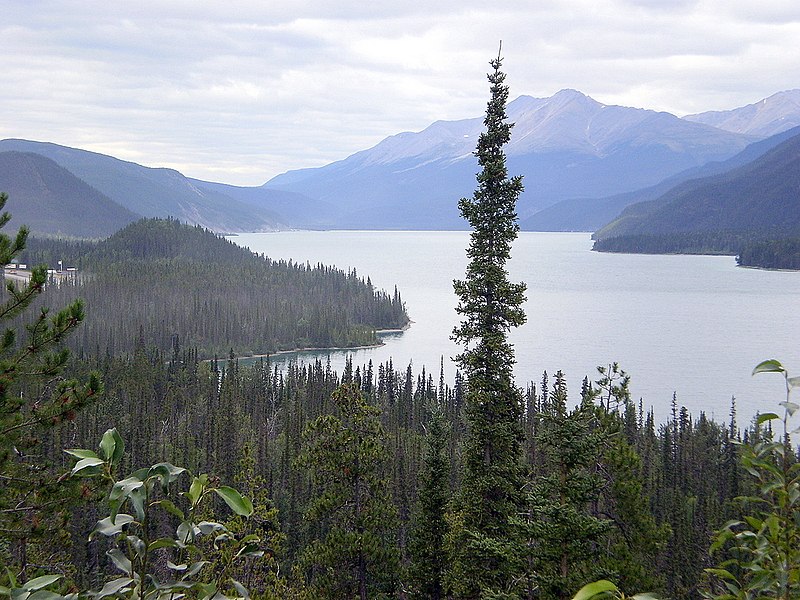
Muncho Lake is twelve km (about 7 ½ miles) long and about 6 km (3 ¾ miles) wide, and is 223 m (732 ft) at its deepest. The colour of the water, a beautiful shade of jade green, comes from copper oxide leaching from the surrounding mountains. It’s a great place for fishing for Arctic grayling, bull trout, lake trout and whitefish
Nature

The lake and park is enveloped by some pretty spectacular geology. Here are three features to look for:
- Folded mountains – caused by millions of years of tectonic plates pushing together and warping the earth’s crust. The geologists at National Geographic describe this action by using the image of pushing on an edge of a table cloth to create a fold. https://www.nationalgeographic.org/encyclopedia/fold-mountain/

https://www.flickr.com/photos/petechar/ Folded mountains and Muncho Lake
- Hoodoos – pinnacle shaped columns of weathered rock, formed when soft deposits of rock are horizontally layered with harder rock such as shale and sandstone, or in the case of the Muncho Lake Provincial Park hoodoos, silt clay deposits. Soft rock erodes faster than the harder rock, and what is left are stacks or pillars of hard rock. We had seen the hoodoos of the Albertan badlands, but these pillars, although formed in the same manner, had different geological makeup, and the end result was a more rugged, scraggy appearance.

- Mineral licks – the geological mineral licks are not like the salt lick blocks that some hunters put out in the fall so they can find their prey easier, (a practice that I find in bad form) but are naturally occurring mineral deposits. They contain sodium, phosphorous, calcium, iron, selenium, cobalt, and other essential elements animals need. Animals help themselves to these deposits to supplement their diet, much as we might take iron or magnesium supplements to keep ourselves healthy.
https://www.thecanadianencyclopedia.ca/en/article/hoodoo-rock

History
First Nations have hunted, fished and harvested in this area for thousands of years. It was the Kaska people that gave the lake its name, Muncho, which means “Big Lake”. In the early 1800’s, European fur traders and trappers made contact and trading routes were established. But there were no European settlements near Muncho Lake until about 1942, when the American Army came through with their trucks and troops to build the Alaskan Highway. Now the nearest community is only about 50 km east. Toad River boasts a lodge, pay phone, gas station, and a population of about 40 people.

Toad River
Back to our adventure
Bob and I were struggling to paddle our canoe against the late afternoon wind that tunnelled down the lake. It didn’t take long to decide we weren’t going to have fish for dinner, and we paddled back to the campsite, built a fire, and enjoyed some perfectly grilled burgers. Bob is an excellent cook!
We stayed at Muncho Lake for 2 nights. The highlight for us was our day trip to Liard Hot Springs Provincial Park. Please read my blog about that here.
Activities in and around Muncho Lake Provincial Park (besides fishing)
- Short walks to long wilderness hikes
- Check out the Peterson Canyon trail. 12 km from beginning to end, but you can park a vehicle at either end if you don’t feel like doing the 24km. https://www.tourismnorthernrockies.ca/listing-item/peterson-canyon/
- Mineral Licks Trail – 1.5 km trail
- Wood Buffalo
- Animal and nature viewpoints along the highway
- Mountaineering
Check out my Great Northern BC Circle Tour blog to read about our adventures in the area
Click here to go to https://648bcparks.ca/my-bucket-list-parks-i-have-visited/(opens in a new tab) for more adventures
One thought on “Muncho Lake Provincial Park – Northern BC”
An interesting read Barb – also like your pics.
Keep on keeping on!
Murray